Agora, a partir da janela de informação do projeto BIMserver.center (que surge quando se clica no nome do projeto visível no canto superior direito da aplicação), é possível aceder à página do perfil público do proprietário na plataforma BIMserver.center através da ligação inserida no texto do nome do proprietário.

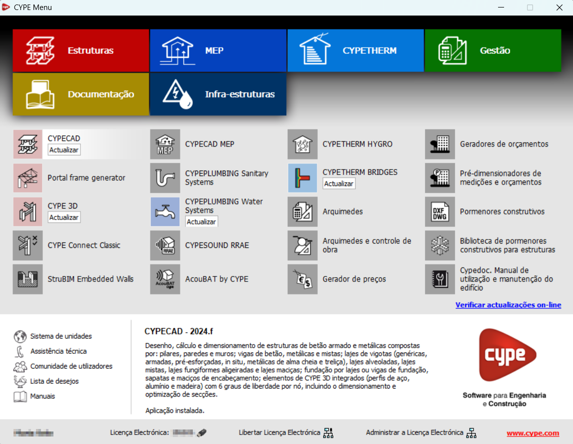
Na versão 2025.a, o CYPE Menu (que se descarrega agora exclusivamente a partir da plataforma BIMserver.center) dispõe de novos grupos de programas.
- Arquitectura
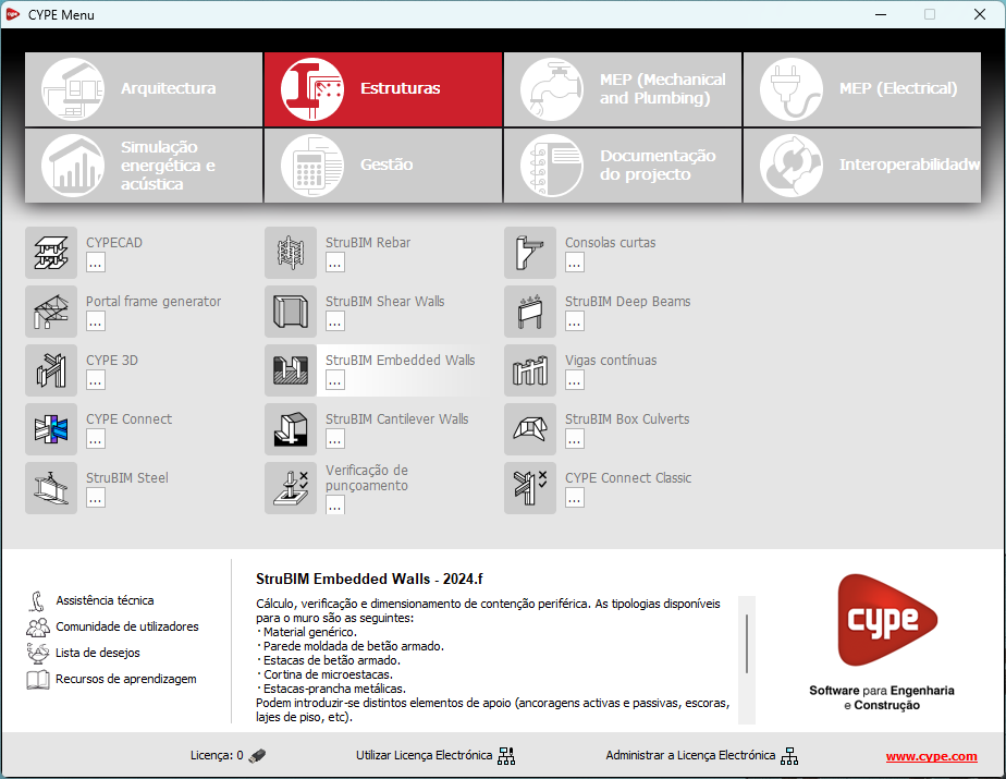
- Estruturas
- MEP (Mechanical and Plumbing)
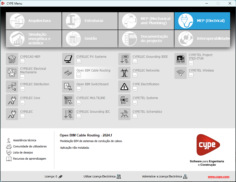
- MEP (Electrical)
- Simulação energética e acústica
- Gestão
- Documentação do projecto
- Interoperabilidade
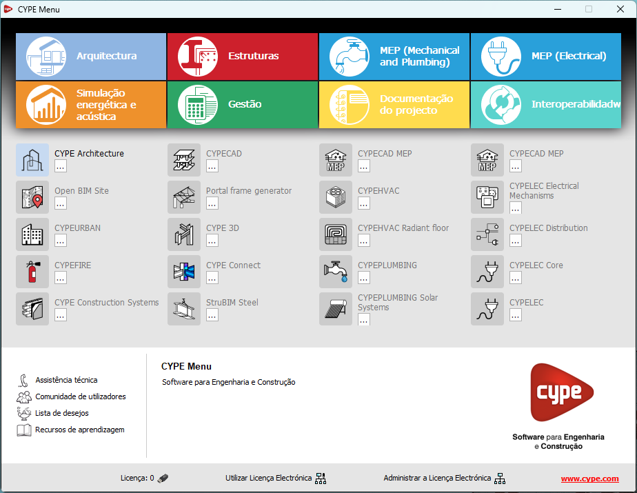
A maioria das aplicações da CYPE estão presentes nestes grupos. Nas versões anteriores, grande parte destas aplicações só podiam ser descarregadas como aplicações individuais a partir da plataforma BIMserver.centre.
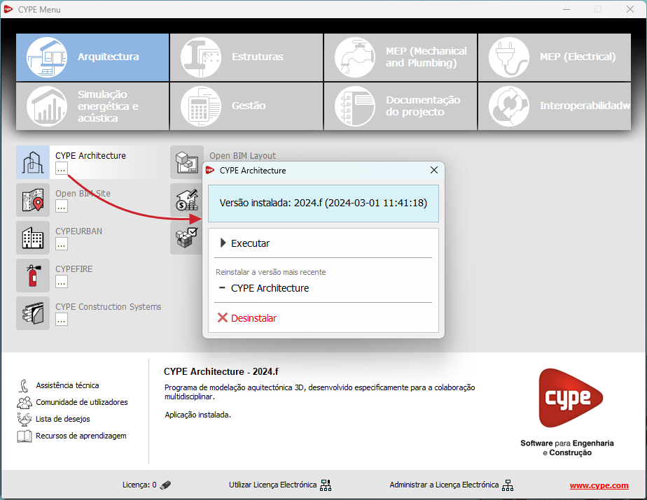
Ao descarregar e instalar o CYPE Menu, o utilizador apenas terá acesso ao menu dos programa CYPE, não serão descarregadas nem instaladas nenhuma das aplicações incluídas no mesmo. Inicialmente, cada um dos ícones que representam as aplicações do CYPE Menu apresenta um fundo cinzento. Ao clicar pela primeira vez num deles (ou no botão sob o nome da aplicação), aparecerá um menu contextual que permitirá descarregar e instalar a última versão dessa aplicação ou uma versão anterior, se estiver disponível. As versões anteriores (a partir da 2024) estarão disponíveis para os programas que incluem módulos pagos. Por norma, as aplicações gratuitas só permitem a instalação da versão mais recente. É possível desinstalar uma versão instalada de qualquer aplicação.
Após a instalação de uma aplicação, se clicar no botão sob o seu nome, o menu contextual que aparece apresenta a opção "Desinstalar".
Na FAQ "Como descarregar e instalar as aplicações do CYPE Menu" encontra mais informações.
A descarga do CYPE Menu de versões anteriores à 2025 (com as aplicações que incluía) encontra-se ainda disponível na área de descarga da página Web da CYPE.
A partir da versão 2025.a, o menu dos programas CYPE descarrega-se exclusivamente a partir da plataforma BIMserver.center.
A aplicação CYPE Menu já estava disponível desde a versão 2024.b na plataforma BIMserver.center. Agora, na versão 2025.a, as vantagens do CYPE Menu relativamente às versões anteriores, que se descarregavam a partir da área de descarga da página Web da CYPE, são:
- A partir da versão 2024.b
- Após a instalação do CYPE Menu, as aplicações são instaladas da primeira vez que são abertas a partir deste novo menu.
- Após a instalação do CYPE Menu, as aplicações são instaladas da primeira vez que são abertas a partir deste novo menu.
- A partir da versão 2024.f
- O CYPE Menu passa a permitir gerir as atualizações das aplicações que possui incluídas.
- O CYPE Menu passa a permitir gerir as atualizações das aplicações que possui incluídas.
- A partir da versão 2025.a
- São incluídos novos grupos de programas e um grande número de aplicações CYPE que só se podiam descarregar diretamente a partir da Store do BIMserver.center.
- É possível selecionar a versão da aplicação que se pretende instalar (a partir da 2024).
- Podem-se desinstalar aplicações já instaladas.
Nas novidades seguintes da versão 2025.a do CYPE Menu, dispõe de informação detalhada sobre as novas prestações.
Na área de descarga da página Web da CYPE, continuará disponível a descarga do CYPE Menu de versões anteriores à 2025.a (em 64 e 32 bits). Encontra-se também, na área de descarga, o link para a "Store" da plataforma BIMserver.center onde pode descarregar a versão 2025.a do CYPE Menu.
Como consequência destas alterações, a versão de 32 bits do CYPE Menu já não está disponível na versão 2025.a. Desde 18 de fevereiro de 2019 (versão 2019.f) que os programas CYPE funcionam em sistemas de 64 bits. Desde então, apenas o CYPE Menu clássico podia ser instalado em sistemas de 32 bits. Todas as restantes aplicações (disponíveis a partir da plataforma BIMserver.center) só funcionavam em sistemas de 64 bits. Consideramos que a programação de 32 bits já não é sustentável para aproveitar as prestações superiores dos processadores e sistemas operativos de 64 bits. Se ainda assim quiser utilizar alguns programas CYPE em 32 bits (os disponíveis no CYPE Menu antes da versão 2025.a), deve instalar uma versão anterior à 2025.a, a partir da área de descarga da página web da CYPE, mas não poderá atualizar os seus programas para versões posteriores. Consulte a nossa pergunta da FAQ Que versão devo descarregar, 64 bits ou 32 bits? para obter mais informação acerca das versões de 32 bits e 64 bits.
A partir da versão 2024.f, a ferramenta CYPE Menu (disponível na Store da plataforma BIMserver.center) permite gerir as atualizações das aplicações que possui.
Ao aceder ao CYPE Menu, o programa verifica se existe alguma versão mais recente das aplicações instaladas e, no caso de existirem, surge junto a elas o botão "Actualizar".
O processo de atualização encarrega-se de realizar a descarga da aplicação e, após a sua finalização, inicia a instalação.
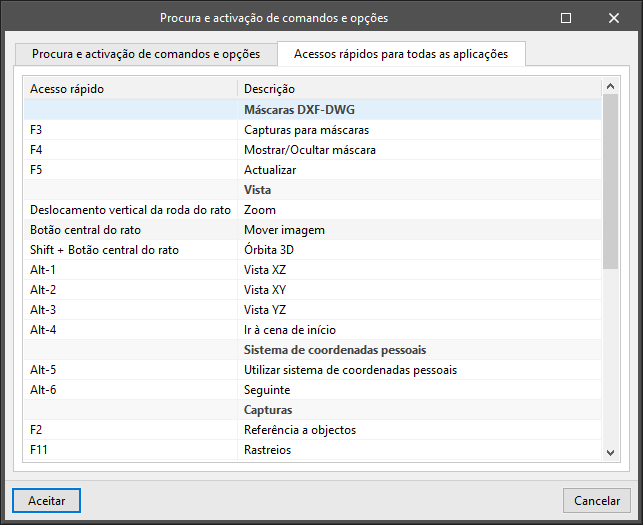
As aplicações da CYPE possuem atalhos de teclado comuns a todas elas. Em versões anteriores à 2024.e, cada programa mostrava os atalhos de teclado particulares de cada aplicação através da opção “Procura e ativação de comandos e opções” que se encontra na parte superior esquerda dos programas.
A partir da versão 2024.e, foi implementado o separador "Atalhos para todas as aplicações" no diálogo que se mostra ao selecionar essa opção e mostram-se todos os atalhos de teclado que são comuns às aplicações da CYPE.
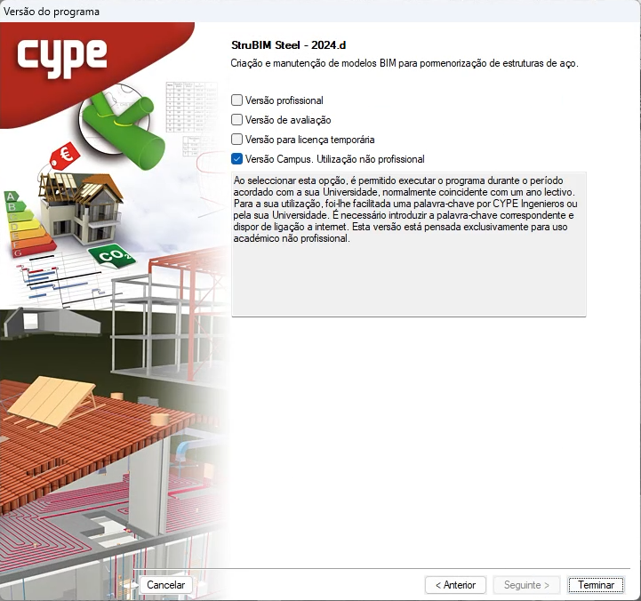
Todos os programas da CYPE podem ser instalados nas suas diferentes versões (versão profissional, versão de avaliação, versão Campus e licença temporária). Nas versões anteriores, apenas a instalação a partir do menu CYPE clássico permitia escolher o tipo de versão que se queria instalar.
A partir da versão 2024.a, foi sendo implementada, na instalação, a seleção do tipo de versão em todos os programas CYPE da plataforma BIMserver.center.
Agora, a partir da versão 2024.d, é possível realizar esta seleção durante a instalação para todos os programas da CYPE, independentemente de onde se descarreguem.
A partir da janela de informação sobre o projeto no BIMserver.center (exibida ao premir sobre o nome do projeto apresentado na barra de informação do projeto - parte superior direita da janela da aplicação) pode aceder à página do projeto da plataforma BIMserver.center através de uma ligação que foi inserida no texto que indica o nome do projeto.
Da mesma forma, a partir da janela de informação sobre as contribuições do projeto (botão "Contribuições" da janela de informação do projeto) é possível aceder à página de cada contribuição na plataforma BIMserver.center. Estas ligações estão inseridas nos textos que indicam o nome de cada contribuição.
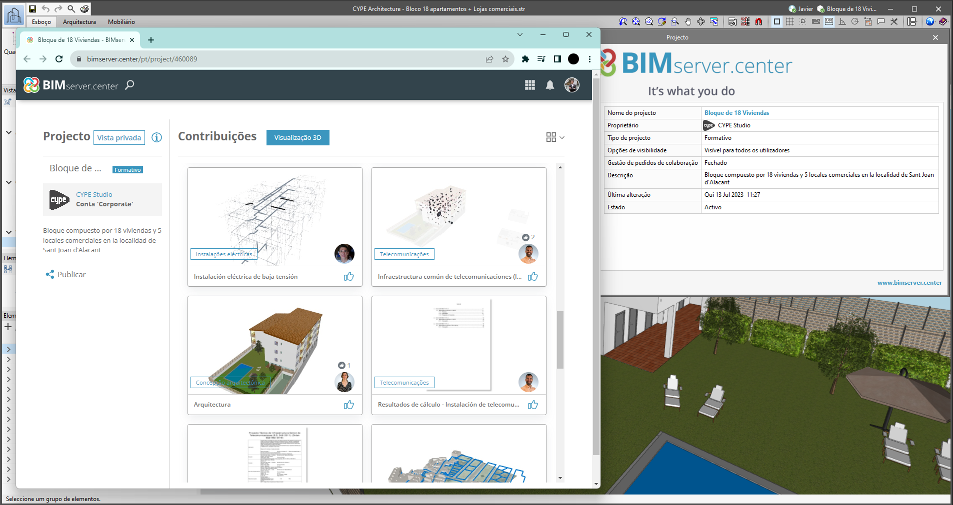
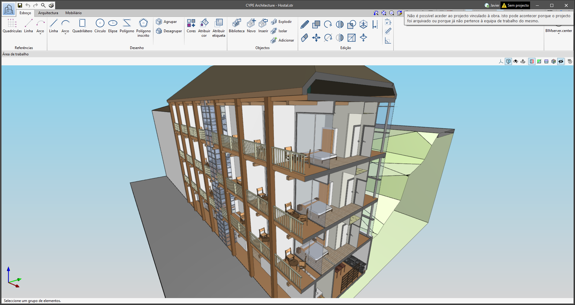
No canto superior direito da janela dos programas incluídos no fluxo de trabalho Open BIM encontra-se a barra de informação do estado do projeto do BIMserver.center. Esta barra está disponível nas aplicações desde a versão 2022.e e apresenta, entre outras coisas, um ícone de aviso quando existe um problema de ligação ao projeto. Agora, na versão 2024.b, é possível obter mais informações sobre o aviso, passando o cursor do rato sobre este ícone.
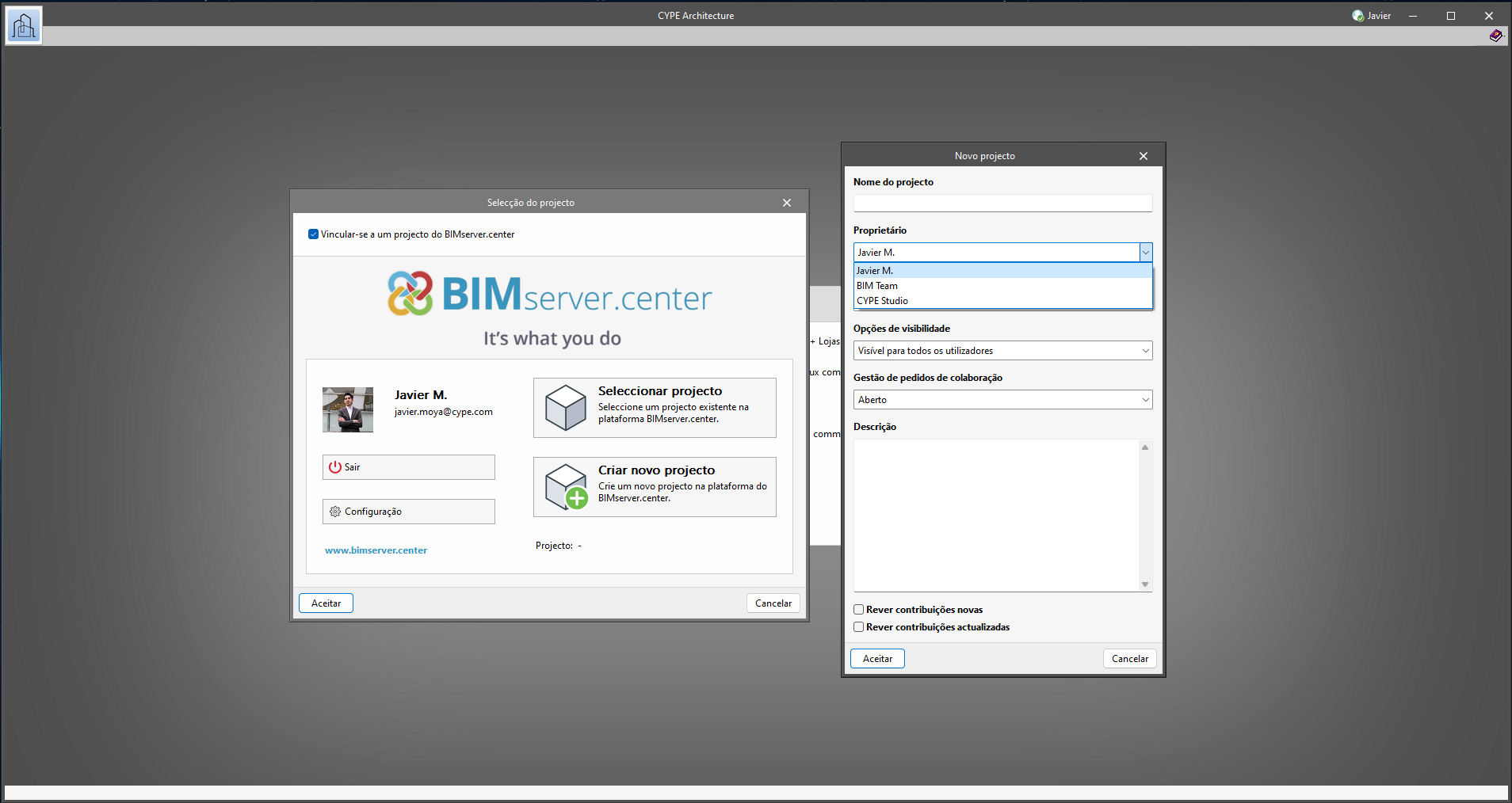
A partir da versão 2024.b, em todas as aplicações da CYPE incluídas no fluxo de trabalho Open BIM, é possível criar projetos associados a uma conta "BIMserver.center Corporate". Para isso, foi adicionado o campo "Proprietário" na janela de criação de um novo projeto. Trata-se de uma lista que inclui, entre as opções disponíveis, o nome de utilizador do BIMserver.center conectado, juntamente com as contas "BIMserver.center Corporate" às quais tem acesso. Se selecionar o nome de utilizador como proprietário, o projeto será associado à sua conta pessoal, tal como acontecia nas versões anteriores. Por outro lado, se for selecionada uma conta BIMserver.center Corporate, o projeto será associado a essa conta.
Nas aplicações da CYPE incluídas no fluxo de trabalho Open BIM, foi adicionado o botão “Eliminar cache” no diálogo "Configuração" que se abre através da seguinte sequência de ações : Selecionar alguma das opções do grupo de ferramentas "BIMserver.center" > botão "Configuração" do diálogo que aparece. Ao premir o botão "Eliminar cache", são apresentadas as seguintes opções:
- Projectos
Elimina os projetos, contribuições e documentos descarregados da plataforma que se encontram no “Directoria de ficheiros armazenados em cache local”. - Sessões
Elimina os dados das sessões ativas. Ao realizar esta ação será necessário voltar a autorizar as aplicações para aceder ao BIMserver.center. - Arquivos de registo
Elimina o registro de transações das aplicações com o BIMserver.center.
