The construction and urban development industry has traditionally followed a workflow where BIM models are integrated into the GIS environment. This process allows users to place detailed information about buildings and infrastructures within a broader geospatial context, which is useful for efficient planning and execution. However, this approach can also lead to the loss of some important data and complicate management due to differences in formats and systems.
Today's demand for more seamless and efficient integration is where Open BIM Site makes a difference. By integrating geospatial data before the creation of BIM models, our program helps to significantly improve model accuracy and relevance, making it easier to plan and execute your projects more effectively.
Thanks to these advances, not only does Open BIM Site optimise your workflow, but it also exploits the potential of both systems and makes a crucial difference in providing you with more accurate and realistic solutions completely free of charge.
How can Open BIM Site transform your workflow?
It's simple: this tool is designed to simplify the first steps in your workflow, allowing you to locate your project more easily and quickly.
Connects directly to national web services
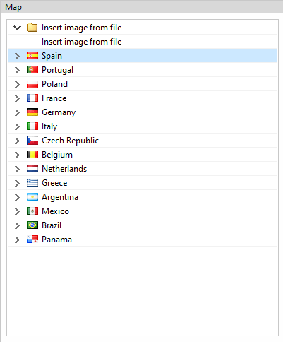
Thanks to its ability to import files in DXF, DWG, JPEG, BMP, PNG, WMF, EMF, PCX and PDF formats from the template manager, Open BIM Site is also able to access WMS web services for specially referenced maps with direct connection to Spain, Portugal, Poland, France, Germany, Italy, Czech Republic, Belgium, Netherlands, Greece, Argentina, Mexico, Brazil and Panama.
This will make it easier for you to connect to national web service data, as well as to obtain maps and topographic surfaces, some of which include specific details such as bus lines and regional cadastre maps.
Benefit from its advanced tools
Location and sites: Detail and place your project in its geographical and urban context. This will give you a clear view of your surroundings, which is essential for decision-making.
Access and nearby dwellings: analyse the access and nearby dwellings to assess the impact of your project on the neighbourhood and existing infrastructure. This perspective will help you anticipate and solve potential future problems.
Parcel geometry: view and analyse the geometry of parcels both from cadastral cartography and ortho imagery.
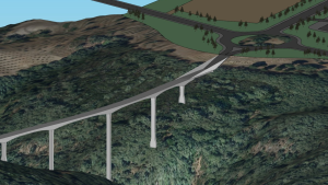
Import building heights: Accurately integrate the height data of existing buildings into your project by generating volumetric (3D) models. This not only allows you to evaluate how your design interacts with nearby buildings, but also makes it easier to analyse visual impact, shadows, and other functional factors.

Integrate topography easily
The incorporation of topographic data is essential for detailed planning. Open BIM Site allows you to integrate topographic data directly into your BIM model quickly and easily. You can do this by simply referencing the databases connected to the program, by using georeferencing data to download the topography or by importing external files with topographic data. This not only improves the accuracy of the ground representation but also helps you to detect possible ground complications and to adjust the design to suit the ground features.

Simplify your work
Open BIM Site stands out for its ease of use. We offer an intuitive interface that allows you to move through the program easily, whether or not you have experience with it.
The Open BIM Site approach
From GIS to BIM
Open BIM Site revolutionises the traditional process by applying a reverse methodology: instead of starting with a BIM model and then integrating it into a GIS environment, the program starts with geospatial data and then builds BIM models. This approach allows design and planning to be based on detailed, up-to-date information about the ground and the environment, rather than adapting the models to this data after it has been created.
Using WPS technology
WPS technology plays a crucial role in the Open BIM Site workflow. It enables the efficient processing and transfer of geospatial data, which improves interoperability and standardisation between different systems and platforms. This ensures that data is handled consistently and efficiently throughout the entire planning and execution process, facilitating the integration of information and coordination between different parts of the project.
A revolution in license management
Open BIM Site revolutionises the workflow in the construction industry by offering an approach that prioritises the integration of geospatial data in the early stages of planning and design. This inverse methodology improves accuracy when creating BIM models, ensuring that each model is aligned with the actual geospatial context and local regulations from the beginning.
Using Open BIM Site means streamlining your current workflow, but also preparing for a more efficient and sustainable future in construction. With advanced tools and an intuitive interface, you can anticipate complications, reduce costs and minimise environmental impact. Ultimately, this free tool sets a new industry standard by combining cutting-edge technology with a strategy that promotes smarter and more responsible construction. It also ensures that the model meets the necessary requirements from the beginning, optimising both job planning and regulatory alignment.