Introduction
CYPEURBAN is a free program that simplifies the generation of documents related to the urban planning compliance of BIM models in IFC format. The program includes logical calculation which allows users to obtain some of the urban planning checks required by municipal bylaws from the BIM model. It also includes a series of tools for defining and checking parameters such as distances from the building to adjoining plots, plot checks, occupancy, buildability, crown height and free heights, among others.
Workflows supported by the program
The option to connect CYPEURBAN to the BIMserver.center platform further expands the working possibilities offered by the program.
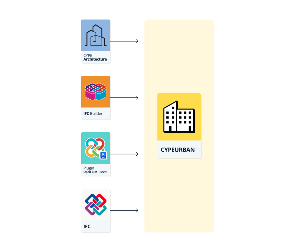
- CYPE Architecture, IFC Builder
These programs are directly connected to the BIMserver.center platform. When the design of the building is completed, the "Share" button in the BIMserver.center section of the toolbar allows the model to be uploaded to the project hosted on the platform so that it can be imported later from CYPEURBAN. - Plugin Open BIM Revit
This program is directly connected to the BIMserver.center platform. When the design of the building is completed, the "Share" button in the BIMserver.center section of the toolbar allows the model to be uploaded to the project hosted on the platform so that it can be imported later from CYPEURBAN. - IFC Uploader
Any project in IFC format that comes from a modeller other than those listed above can be uploaded to BIMserver.center via this program.
Space import assistant
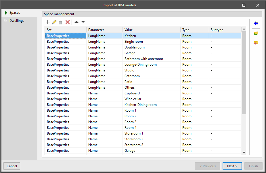
The BIM model's space import assistant automates the definition of computable and habitable surfaces.
This assistant has tools for filtering the spaces (IfcSpace) of any IFC model based on their properties and associating them with useful surfaces or built surfaces. This assignment also allows the subtype of the surface to be specified. For net floor areas, one of the uses contemplated in the selected urban regulations can be selected, and for built surfaces, one of the user-defined computation coefficients can be specified.
The import tables defined in the assistant can be saved as libraries to be imported into other CYPEURBAN projects. Therefore, users can make the import of net floor areas and built surfaces completely automatic after the first import, regardless of the BIM tool used to create the building model. These libraries will be valid even for importing BIM models from different applications, as long as the same nomenclature criteria are followed for all files.
Work environment
The CYPEURBAN work environment is similar to other CYPE modelling tools and has an interface that is divided into three main parts:
Modelling area
The modelling area can be found on the right-hand side of the screen and is completely three-dimensional, allowing 2D and 3D views to be created and previously defined workplanes to be used. Furthermore, this is where all the elements of the project are entered, edited and viewed in 3D.
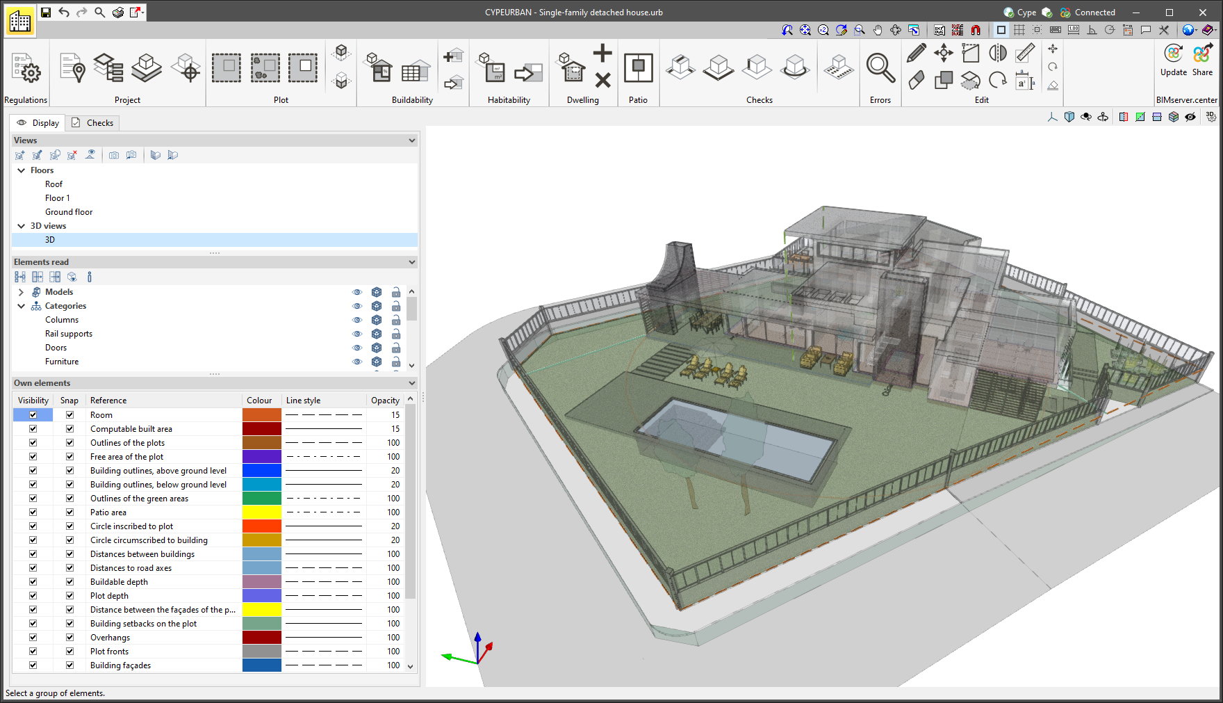
Sidebar
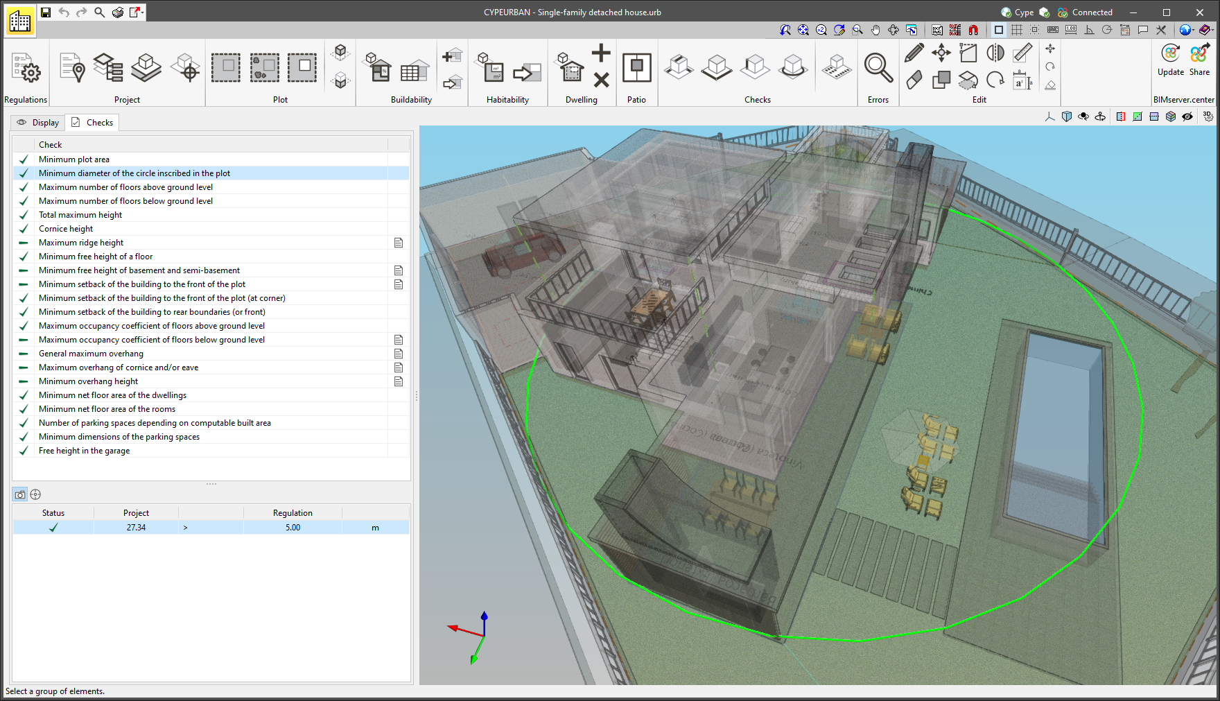
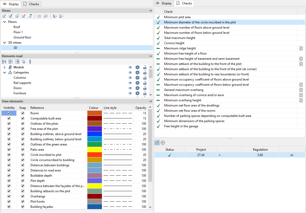
This bar has two tabs with different functions. From the "Display" tab, both the type of view and the visibility of the building’s elements and its urban planning checks are managed. From the "Checks" tab we can access the check report of the applied regulations.
- Display
- View
Allows 3D model views to be created (floor, elevation, section, 3D). - Read elements
Allows the models of different disciplines (architecture, MEP, structures, etc.), the different categories of the models (columns, walls, floor slabs, etc.) of the elements imported into the project, and the different regulatory checks to be switched on, switched off or made transparent. - Own elements
Allows the colour, line style and opacity of the different regulatory checks to be viewed, snapped and edited.
- View
- Checks
- List of checks
Shows a panel with a list of the checks that must be complied with in a given municipality. From here, users can access the list of checks and find out whether or not they are compliant. Double-clicking on a check will open a panel containing an explanation of the regulations. - Table of checks
Each check has an associated table in which the checks of the same type are displayed. The table contains the code values and the values of the BIM model, as well as other data.
- List of checks
Toolbar

The program has a new toolbar that provides more functionality and groups different elements together. The sections of the toolbar are as follows:
Regulations
From here, users can access a report that includes all the available urban checks, manage the municipality checks, and create or upload other urban planning checks not included in the selected regulations.
CYPEURBAN allows users to create and load the specific urban regulations of the municipality where their project is to be carried out. Regulations must be entered into the program to begin checking a BIM model.
This section, which can be accessed from the toolbar, has many different checks that allow users and city councils to digitise the urban regulations of the municipality.
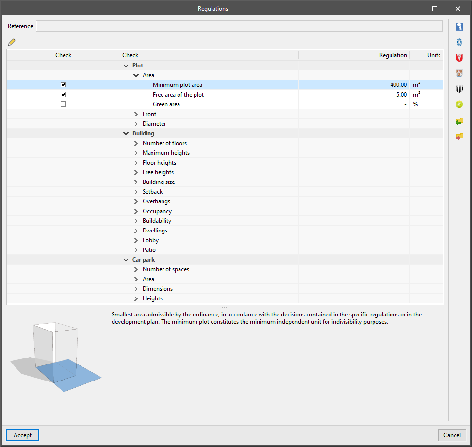
The checks available in the program to generate user-defined regulations are sorted according to the type of check:
- Plot
- Area
Minimum plot area, free area of the plot, and green area. - Front
Minimum front width, and depth to front ratio of the plot. - Diameter
Minimum diameter of the circle inscribed in the plot.
- Area
- Building
- Number of floors
Maximum number of floors above and below ground level, and maximum number of storeys depending on the adjacent buildings. - Maximum heights
Total maximum height, maximum total height depending on the adjacent buildings, maximum crown height, cornice height, maximum ridge height, maximum height of plot fencing, maximum façade height depending on adjacent buildings and maximum height depending on the width of the road. - Floor heights
Minimum floor height of the ground floor, minimum floor height of the floor and height of floor below ground level. - Free heights
Minimum free height of attic, floor, ground floor, mezzanine floor, basement and semi-basement. - Building size
Façade with greatest length, maximum diameter of the circle circumscribed to the building, buildable depth, minimum distance to road axes, minimum distance of buildings of the same plot, and maximum depth of floors below ground level. - Setback
Minimum setback of the building to the front of the plot (at corner, general), minimum setback of the building to rear boundaries (or front), minimum setback of attics with respect to the façade, and minimum setback of underground construction. - Overhangs
General maximum overhang, maximum overhang of balconies, long balconies, enclosed balconies, terraces, cornices and/or eaves, and minimum overhang height. - Occupancy
Maximum occupancy coefficient of floors above and below ground level. - Buildability
Maximum buildability coefficient, minimum buildability coefficient and maximum buildable area of the net plot or depending on use. - Dwellings
Maximum number of dwellings, minimum net floor area of the dwellings and the rooms. - Lobby
Maximum length of the lobby, maximum depth of the lobby and crown height of the lobby. - Patio
Minimum distance between patio façades, minimum area of patios, maximum height of patio.
- Number of floors
- Car park
- Number of spaces
Number of parking spaces per dwelling, number of parking spaces depending on computable built area. - Area
Total area dedicated to parking spaces, with respect to the area of the plot, and minimum area of the parking spaces. - Dimensions
Minimum dimensions of the parking spaces. - Heights
Free height in the garage.
- Number of spaces
Furthermore, thanks to the collaboration with different municipal entities, the program currently includes the check libraries of the following municipalities:
- Madrid
Norma zonal 5 del (PGOU 1997), plan parcial Mahou-Calderón, Los Berrocales
- Rivas Vaciamadrid
PGOU (2003): plan parcial Cristo de Rivas, plan parcial Las Colinas, plan parcial La Fortuna, plan parcial Mirador Norte, ZOUP. 9.
- Leganés
PGOU (1999): plan parcial Ampliación Portillo, plan parcial puerta de Fuenlabrada, plan parcial Pozo Agua y plan parcial Solagua.
- Rennes
Plan local d’urbanisme de la Ville de Rennes: UB1, UB2, UB3.
- Vila Nova de Gaia
RGEU, RMUE y Plano Diretor Municipal. - Lisboa
Project
Contains the project’s general data:
- Description
Here, the project data (name, cadastral reference, road, etc.) and the data of the specialist in charge of the project will be specified. In the Spanish and Catalan version, a connection has been established with the Spanish cadastre web service called 'Sede Electrónica del Catastro' which allows some of this data to be downloaded. - Floors
From here, everything related to the floors of the model can be managed, and a free height can be associated with each of them. All the floors of the building must be checked before exporting the job. - Location
Allows the roads surrounding the building to be added, as well as the width of the roads. This data can be used later in height checks. - Reference elevation
Allows the elevation at end or the ground level elevation of the building to be specified. This data can be used later in height checks.
Plot
Here the building plot, the green area and the occupancy above and below ground level are defined.
Buildability
This section contains a library of computable built area types. The library includes three default area types: 100% computable, 50% computable and non-computable. Users can create new types of computable built areas. Each type of surface can then be entered manually or imported using the space import assistant.
A table is also included that displays all the computable built areas of the site and allows users to browse through them while highlighting them in the 3D model. The table allows the areas to be sorted according to computation, use or floor.
Habitability
This section is used to manage the data for checking the habitability of the building. The spaces can be created directly in the program or imported from the BIM model using the space import assistant.
Dwelling
Allows spaces to be grouped to manage dwelling units. This data will be used to carry out checks on the size and number of the dwelling.
Patio
This section carries out the checks regarding the patios, such as the minimum area of the patio, the minimum distance between patio façades and the maximum height of the patio.
Checks
This section covers most of the program's checks. These checks are organised into length (setback, buildable depth, overhang, etc.), front (plot and building), heights (maximum height, ridge, penthouse, etc.),circle (plot and building) and parking spaces.
Edit
This section contains the main tools for editing the model.
| Edit | Selects an element in the model and edits its parametric properties. | |
| Delete | Deletes a previously entered element. | |
| Move a group of elements | Moves a group of elements. | |
| Copy | Copies the selected elements. | |
| Move | Moves the edge or corner of the selected element. | |
| Copy to another level | Copies the selected elements to another given level. | |
| Symmetry | Copies a selection of elements with symmetry with respect to a vertical plane defined by two points. | |
| Rotate | Rotates the selected elements around two given points. | |
| Measure lengths | Allows you to measure the distance between points inserted in the work area. | |
| Measure area | Allows users to measure the area of a polygon defined by points inserted in the work area. |
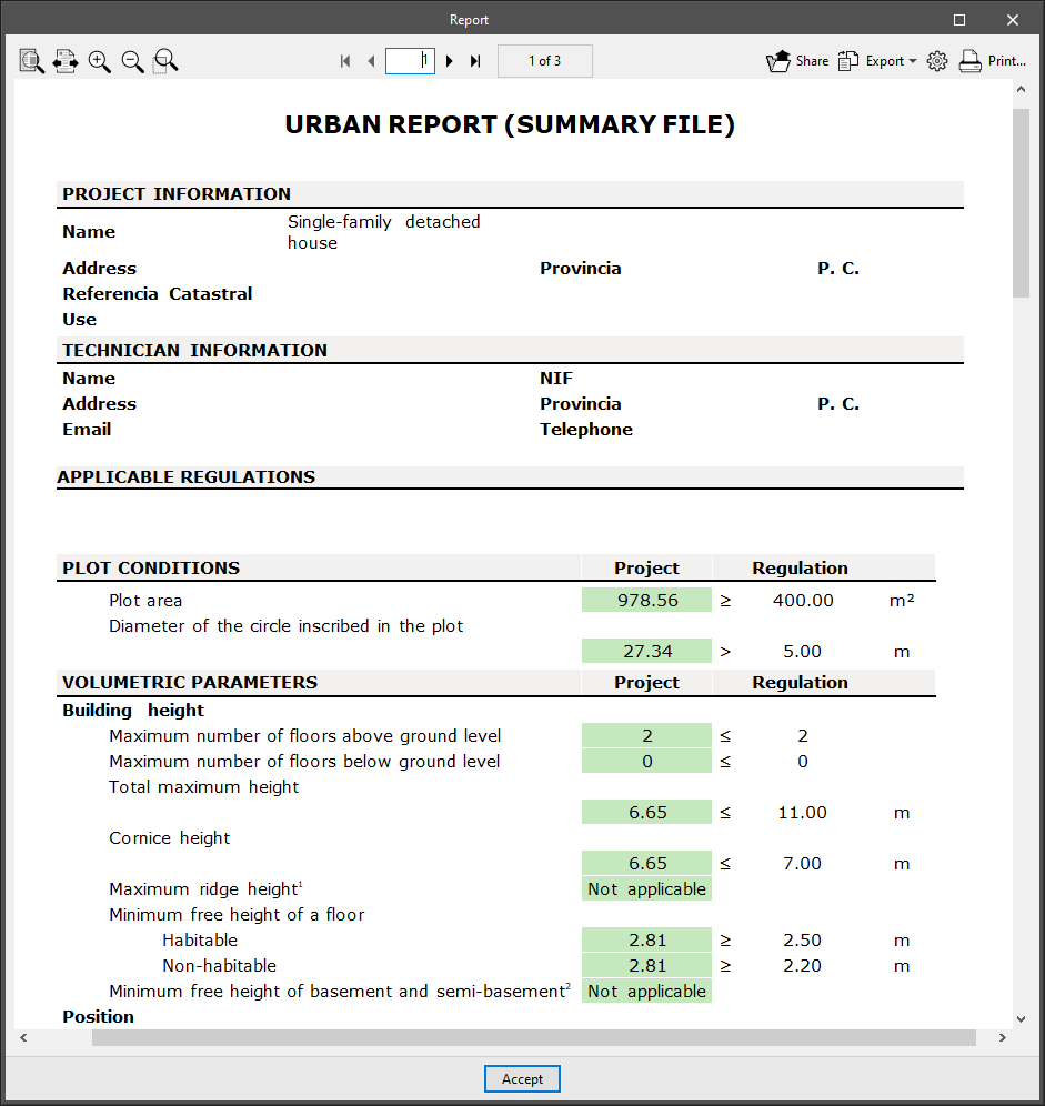
Report and BIM model of urban regulations
CYPEURBAN provides a compliance report of the urban regulations that displays the results as a comparative table, comparing the value of the regulation and the value of the project. It includes tables with a breakdown of habitability and parking spaces.
The program also allows users to export the BIM urban planning model and its checks to IFC so that it can be verified later using a BIM viewer, e.g. Open BIM Model Checker.
Integration into the BIMserver.center platform
Many of CYPE's programs are connected to the BIMserver.center platform and allow collaborative work to be carried out via the exchange of files in formats based on open standards.
Please note that, to work on BIMserver.center, users can register on the platform free of charge and create a profile.
When accessing a program connected to the platform, the program connects to a project in BIMserver.center. This way, the files of the projects that have been developed collaboratively in BIMserver.center are kept up to date.

| More information: |
|---|
| For further details related to using CYPE software via the BIMserver.center platform, please click on this link. |
Options available in CYPEURBAN
The main toolbar contains the necessary features for using CYPEURBAN together with other BIMserver.center tools.
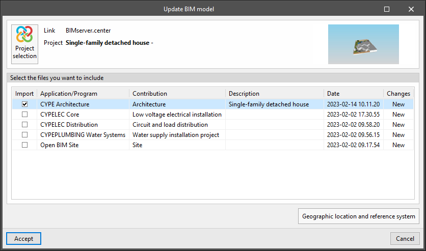
Importing and updating BIM models
The "Update" button can be used to update the information contained in the models previously imported into the project or to import new models if desired.
Models are imported according to the defined configuration and users can choose how new, modified and deleted elements of the BIM model are shared.
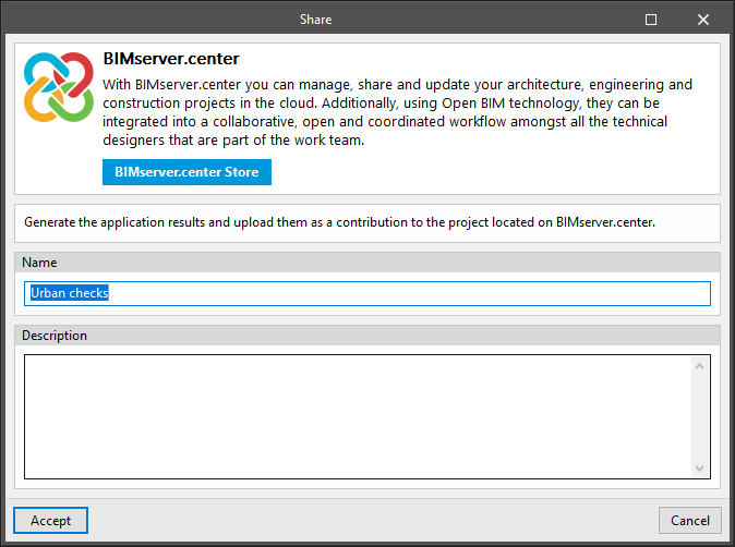
Exporting the BIM model to share it with other users
The "Share" button can be used to export the information contained in the model developed with CYPEURBAN to BIMserver.center.
During the export process, users can define information related to the identification of the files that will be shared.